
Ouachita Trail: Winding Stair Recreation Area to Highway 259
29 free downloadable topo maps of the Ouachita Trail. Available for purchase.
 Winding Stair Recreation Area to Highway 259. The track for this section was provided by JD Blackwell. JD headed up the volunteer Ouachita Trail maintenance effort for the Green Country Outdoor Club (find them on Facebook) and was a member of the FoOt, Friends of the Ouachita Trail.
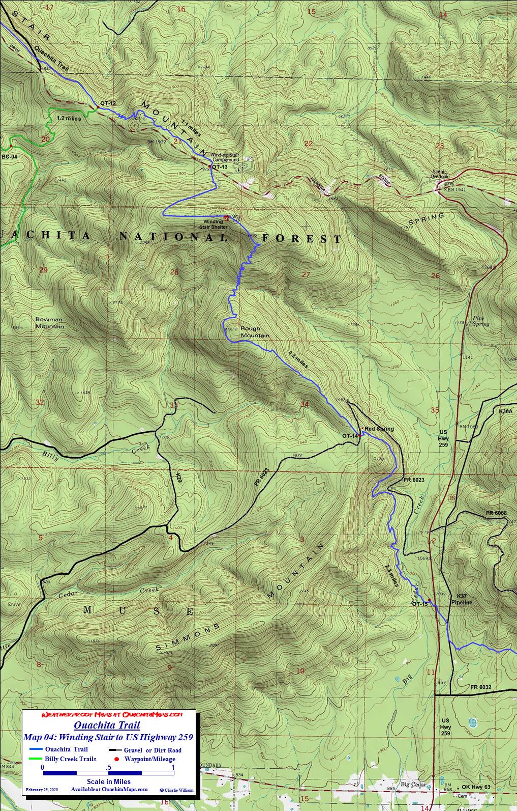
This map actually starts closer to Horse Thief Springs and includes the junction of the east Billy Creek Trail with the Ouachita Trail. The OT stays on the north side of Talimena Drive and travels southeast to the hiker's parking lot west of the Winding Stair Recreation Area. The trail crosses the scenic drive to the south and goes up a forest road to the top of West Billy Peak (2451 ft) and the Winding Stair Shelter. After crossing a saddle to East Billy Peak, the trail makes a steep decent using 26 switchbacks to a saddle (1780 ft) and then ascends to near the top of Rough Mt (2171 ft). Now it is a gradual down hill along a ridge to FR 6023. There is a hunters camp near the intersection and usually water in Red Spring.
The trail continues down hill, working its way down the east side of Simmons Mt until it crosses Cedar Creek. While Cedar Creek is a dependable water source the draw back about camping on it is its proximity to the traffic on US 259. The trailhead parking lot on US259 is on the west side of the highway.
The next section of the Ouachita Trail is US 259 to Queen Wilhelmena State Park.
Shuttles: Hiker shuttles are available from D&W Store (also known as Big Cedar Store, 918-651-3230), Big Cedar RV Park (918-651-3271) and Talking Talking Trees Campground (918-653-2187). Be sure to call ahead and make arrangement as neither is set up for drop in business.
The Maps: The maps provided here are free to download. They are 1:24,000 based on USGS 7.5 minute quads and formatted to print on 11x17 paper.
To Buy Maps: Color weatherproof versions (11x17) of each map are available for $5 each plus S&H by emailing Charlie at cew5151@gmail.com (you will proably need to cut and paste the address into your email app).